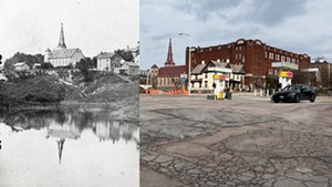
The serpentine ravine that bisected Burlington up until the end of the 19th century is the stuff of legend. It's hard to imagine, but the city's downtown was separated from the Hill Section by a deep gully with a stream running through it. The ravine was most likely thousands of years old and more than a mile long.
From the Old North End, the gulch twisted across Pearl Street and through the downtown core — including where the Fletcher Free Library now stands — emptying into Lake Champlain south of Maple Street. Where the former VFW building and the Hood Plant parking lot are now, the ravine was about 25 to 35 feet deep and may have stretched as wide as a city block. Multiple bridges allowed people and carts to pass over the chasm.
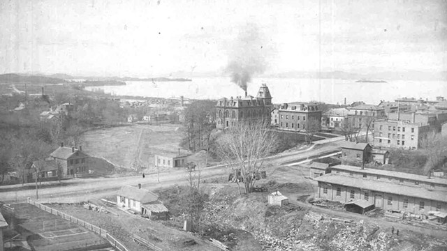
- Courtesy Of Silver Special Collections, University Of Vermont
- 1882 view of the partially filled-in ravine, the diagonal ravine sewer and Main Street
As if this weren't weird enough, in the 1850s the Vermont Central Railroad used the ravine as a train route to connect Burlington to its main line in Essex Junction. After the track was relocated in the early 1860s, the gully became an open sewer and garbage dump. Then, in the 1870s, a brick-and-stone sewer was built in the gulch, and the area around it was filled in. But signs of the ravine remain, if you know where to look.
Over the years, many people have become obsessed with documenting this unusual geologic feature that defined the Queen City's early history. The ravine attracts cultlike interest, and local historians have dug into its secrets.
Recently, there has been a lot of literal digging, too. As part of its Great Streets Initiative, the Department of Public Works is rerouting the flow of the approximately 150-year-old ravine sewer. This much-needed infrastructure work will allow for aboveground improvements in the next few years.
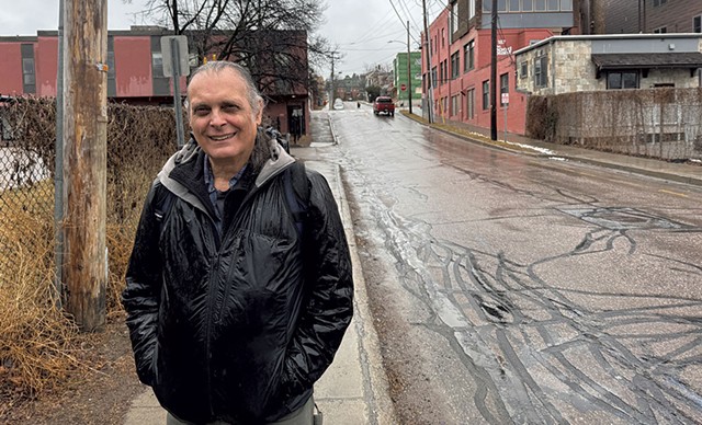
- Eva Sollberger ©️ Seven Days
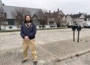
- Hugo Martínez Cazón on King Sreet
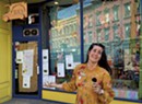
In her latest episode of "Stuck in Vermont," Seven Days senior multimedia producer Eva Sollberger joined the ravine-obsessed. She toured the area with engineer and self-described "map geek" Hugo Martínez Cazón and pored over old maps with Jeffrey Marshall, library professor emeritus, at the University of Vermont's Silver Special Collections. She viewed two portions of the recently uncovered sewer with DPW senior engineer Laura Wheelock and, with DPW director Chapin Spencer, examined some of the historic bottles that have been unearthed during this massive project. She even climbed to the top of the College Street Congregational Church steeple to get a bird's-eye view.
Sollberger spoke with Seven Days about filming the episode.
What sparked your interest in the ravine?
Like most Burlingtonians, I had heard about the ravine for years. It has a mythic quality to it, and I could not imagine what it might have looked like in the middle of our city. And, of course, people are curious about the excavation around the gully.
Someone sent a brief email to DPW director Chapin Spencer and Seven Days publisher Paula Routly, asking if anyone was documenting the ravine sewer work. I volunteered. I didn't realize what I was getting into. The ravine is mysterious and complex. The deeper I dug, the more questions I had. And that is what makes the ravine so stimulating. It has endless secrets, and we will never uncover them all.
Where can we see signs of the ravine around town?
If you want to take a tour, visit King Street where it nose-dives like a roller coaster between South Winooski Avenue and lower Church Street. From the middle of the dip, you're basically standing where the ravine was. Look north to Main Street, and you will see a steep hill. To the south, the Hood Plant parking lot was once a large pond, and a precipitous hill along its southern edge shows the lip of the ravine.
Similarly, a dipped parking area between City Market, Onion River Co-op and College Street shows the depth of the ravine.
Looks like it took a lot of legwork to make this video.
This video took about five filming days and countless emails and phone calls. I certainly got my steps in and walked all over town trying to re-create old photos of the ravine. Most of the buildings are gone, but the churches remain, making them very helpful landmarks for getting oriented.
Probably my two favorite shoots were climbing up the church steeple and also peering inside two uncovered sections of the old ravine sewer. I actually gasped when I first saw it. Raw sewage generates heat, and I could feel the warmth. And, of course, there was a ripe smell.
Imagine living in Burlington in the 1860s, when there were open sewers flowing through the uncovered ravine. I heard that people, horses and carts sometimes fell in, and garbage piles spontaneously combusted. It wasn't all bad, though: The ravine was used for a toboggan slide, and Martínez Cazón imagines that it may once have been filled with apple orchards.
Who knew Burlington had so many ravine history buffs?
I want to thank everyone who spoke to me about the ravine, both on and off camera. People were very generous with their time and expertise. I tried to credit them all at the end of the video. Mary O'Neil, the principal planner for the City of Burlington, provided an important map and helpful newspaper clippings.
Bob Blanchard runs the Facebook page Burlington Area History, and he provided tons of material and context. His page has many helpful mentions of the ravine and is a great resource for local history buffs.
Tell us about the view from the College Street Congregational Church steeple.
That was a real highlight of this experience. Thanks to William Northup and Tim Gibbo for giving me a tour of this beautiful church and safely conveying me up the endless steep steps. They even let me ring the church bell — twice. My apologies to the pigeons.
It is amazing to see the Queen City from this height and to note how much the landscape has changed. Filming this video made me appreciate the fluid nature of our town. The scenery is ever changing, and I look forward to seeing what comes next.
This story was updated on April 14, 2024, to correct the date when the ravine existed.


Comments
Comments are closed.
From 2014-2020, Seven Days allowed readers to comment on all stories posted on our website. While we've appreciated the suggestions and insights, right now Seven Days is prioritizing our core mission — producing high-quality, responsible local journalism — over moderating online debates between readers.
To criticize, correct or praise our reporting, please send us a letter to the editor or send us a tip. We’ll check it out and report the results.
Online comments may return when we have better tech tools for managing them. Thanks for reading.