I like to read, but I don’t like to read outdoorsy books very much — which is probably how my husband and I ended up completely lost in a canoe on the Lamoille River one summer. Had we bothered to actually read the guidebook a friend had given us, we would have known that we needed to shuttle back to our starting point. And we probably would have avoided the panic, the hunger, the broken paddle and the embarrassing hitchhike back to our car. (Though, I must say, those hamburgers at Joe’s Snack Bar in Jericho have never tasted better.)
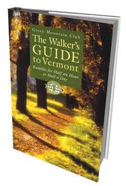
So it was with determination to be a better recreational reader that I agreed to check out three 2009 tomes about human-powered travel around the state. At first, The Walker’s Guide to Vermont: Rambles for Half an Hour or Half a Day (published by the Green Mountain Club in June) seemed like precisely the wrong book with which to start fulfilling my resolution. With all the great hiking in this state, who needs a book about walking?
Well, me, for one. With two toddlers who can barely climb into the car, let alone up a 4000-foot mountain, my forays to the summits of Mount Abraham and Mount Mansfield have been put on hold for a while. (Yes, there are backpacks, but my husband and I nearly froze our daughter’s feet off when we hiked up Camel’s Hump without reading, er, a weather report one October.)
And I know there are thousands of other Vermonters who don’t have the time, energy, ability or desire to constantly bag peaks. Instead, one could bag, say, the Bog Boardwalk Trail, a half-mile trot through the Westmore Town Forest. Or the 0.7-mile meander to the Falls of Lana. Or the 1.25-mile Wood Thrush Loop in Springfield’s Hartness Park.
The Walker’s Guide provides information on wheelchair- and stroller-accessible trails, old carriage roads, urban thoroughfares such as Burlington’s Recreation Path, and agricultural access points, including Shelburne Farms and Woodstock’s Billings Farm. The trivia is as interesting as the trailheads; the peripatetic reader can learn, for example, that black gum trees abound in Brattleboro, and that Chipman Hill was once Middlebury College’s ski slope. With easy-to-follow maps, inspiring photos, pointers to portable toilets and just the right number of pages (248) to stuff in a back pocket for the backpack-shy, the new guidebook is just about the nicest first step a Green Mountain State walker can take.
Those seeking a little more altitude may prefer A Century in the Mountains: Celebrating Vermont’s Long Trail (also published by the Green Mountain Club). Trying to tuck it in your Patagonia pocket would be a backaching mistake; this is a hardcover coffee-table book for serious hikers and armchair travelers alike. And, unlike a guidebook that aims to get you going in the right direction, A Century in the Mountains could sidetrack even the most enthusiastic mountaineers into a long, lazy reading session on the couch.
From the opening spread of Mount Mansfield’s golden, red and boulder-strewn summit to the final shot of the western view from Camel’s Hump in the fall, the photos promise what awaits us after the winter. (Though images of a frosty Mount Abraham and Green Mountain Club founder James Paddock Taylor on a winter hike are reminders that the mountains are pretty nice now, too.) Photographers include Brian Mohr, Jeb Wallace-Brodeur and Alden Pellett, who share their stuff alongside shots from the GMC archives of 1919 Long Trail campers, the 1970s “boom years” of hiking and the new wheelchair-accessible trail at Thundering Falls in Killington.
But the real story of A Century in the Mountains is how the Long Trail came to be, as told by Tom Slayton and other contributors. During the Champlain Quadricentennial festivities last July, partygoers listened to The Roots and other bands on the Burlington Waterfront and checked out an Abenaki encampment outside ECHO. But in July 1909, as the book explains, history buffs celebrated the tercentennial by gathering in City Hall Park and listening to President Taft and other officials, one of whom urged Vermonters to “keep open the mountains, and allow no one to debar pedestrians from climbing to their tops and wandering along their slopes.”
By the following March, plans for the Long Trail were in the works. And, as the GMC president explains in A Century in the Mountains, the trail has helped “rewild” the states. Vermonters’ loyalty to the long footpath tracing the Green Mountains’ spine, he notes, “may prove to be even more resilient than some of our other twentieth century icons, such as maple syrup, dairy farms, colorful fall foliage and old barns.” As Bill McKibben writes in the book’s foreword, “The Long Trail has helped maintain the larger work of Vermont environmentalists, given us a place to remember why we’re fighting and what the stakes really are.”
Much the same could be said of Lake Champlain. A Kayaker’s Guide to Lake Champlain: Exploring the New York, Vermont & Quebec Shores, a 320-page book by Cathy Frank of South Burlington and Margy Holden of Shelburne (Black Dome Press), is partly an homage to Samuel de Champlain, and it’s rich with history and environmental insights.
The lively descriptions of 50 different routes are likely to lure would-be paddlers to ply Lake Champlain’s waters. Frank and Holden, who both have houses in the Champlain Islands, have kayaked all the places they write about, and their first-person accounts are entertaining, if not always enticing. Take, for example, the report on Missisquoi Bay, which the women admit they “did not look forward to paddling,” owing to the greenish algae bloom and unclear border-crossing directions. But 23 miles, a yellow customs phone and some “reed music” later, Frank and Holden are calling the area “a wondrous place where water and land blend and wild things are protected.”
Occasionally, the duo’s writing can seem a bit ornery and self-righteous; a section on “Broad Lake East,” aka the Burlington area, fusses over the kids “illegally jumping” from the cliffs at Red Rocks Park and a cigarette boat that gets 4 miles to the gallon. But I loved learning about some lake landmarks (Juniper Island, the Shelburne shore shale) that have long aroused my curiosity during my own time on the water. And I’m already looking forward to weather warm enough to paddle the 12-mile Knight and Butler islands route that Frank and Holden describe. I’m pretty sure A Kayaker’s Guide will keep me out of trouble.


![Art From the Heart [SIV342]](https://media1.sevendaysvt.com/sevendaysvt/imager/art-from-the-heart-siv342/u/review/2297986/stuck021214.jpg)


Comments
Comments are closed.
From 2014-2020, Seven Days allowed readers to comment on all stories posted on our website. While we've appreciated the suggestions and insights, right now Seven Days is prioritizing our core mission — producing high-quality, responsible local journalism — over moderating online debates between readers.
To criticize, correct or praise our reporting, please send us a letter to the editor or send us a tip. We’ll check it out and report the results.
Online comments may return when we have better tech tools for managing them. Thanks for reading.